Explore the very diverse range of hiking scenery close to Granada
Within about an hour’s drive from Granada, there are many fantastic hiking opportunities offering diverse landscapes, ranging from dramatic gorges to alpine trails. Here are some of the best hikes you can easily access from Granada:
Some Hiking Highlights!
1. Los Cahorros de Monachil (Monachil Gorge) (15 min from Granada)
- Highlights: Hanging bridges, narrow canyons, river scenery, adventure trails.
- Length: 8–10 km (Circular).
- Duration: 3–4 hours.
- Difficulty: Easy to moderate.
- Best for: Families, adventurous hikers.
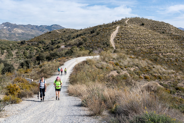
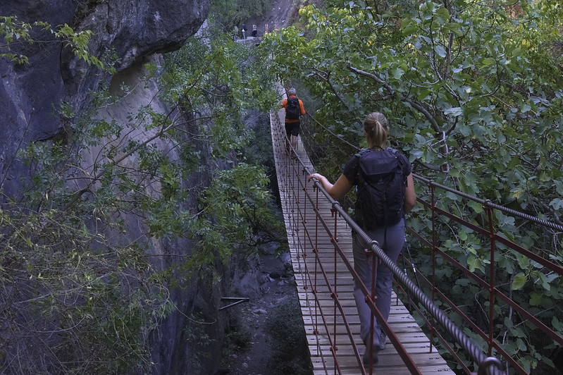
2. Ruta del Gollizno (Moclín) (35–40 min from Granada)
- Highlights: Hanging bridges, waterfalls, archaeological cave paintings, panoramic views of Moclín Castle.
- Length: ~9 km (Circular).
- Duration: 3–4 hours.
- Difficulty: Moderate.
- Best for: Nature lovers, cultural hikers.
3. Sierra Elvira Trails (Atarfe) (20 min from Granada)
- Highlights: Mountain views, geological features, panoramic vistas of Granada and Sierra Nevada.
- Length: Various trails (5–10 km).
- Duration: 2–4 hours.
- Difficulty: Easy to moderate.
- Best for: Short hikes, geology enthusiasts.
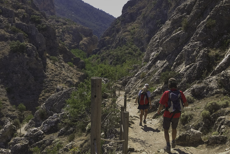
6. Tajos de los Bermejales (Embalse Bermejales) (40–45 min from Granada)
- Highlights: Impressive limestone cliffs, turquoise reservoir views, river scenery.
- Length: 10–12 km (Circular).
- Duration: 3–4 hours.
- Difficulty: Moderate.
- Best for: Scenic landscape, swimming opportunities, relaxed hiking.
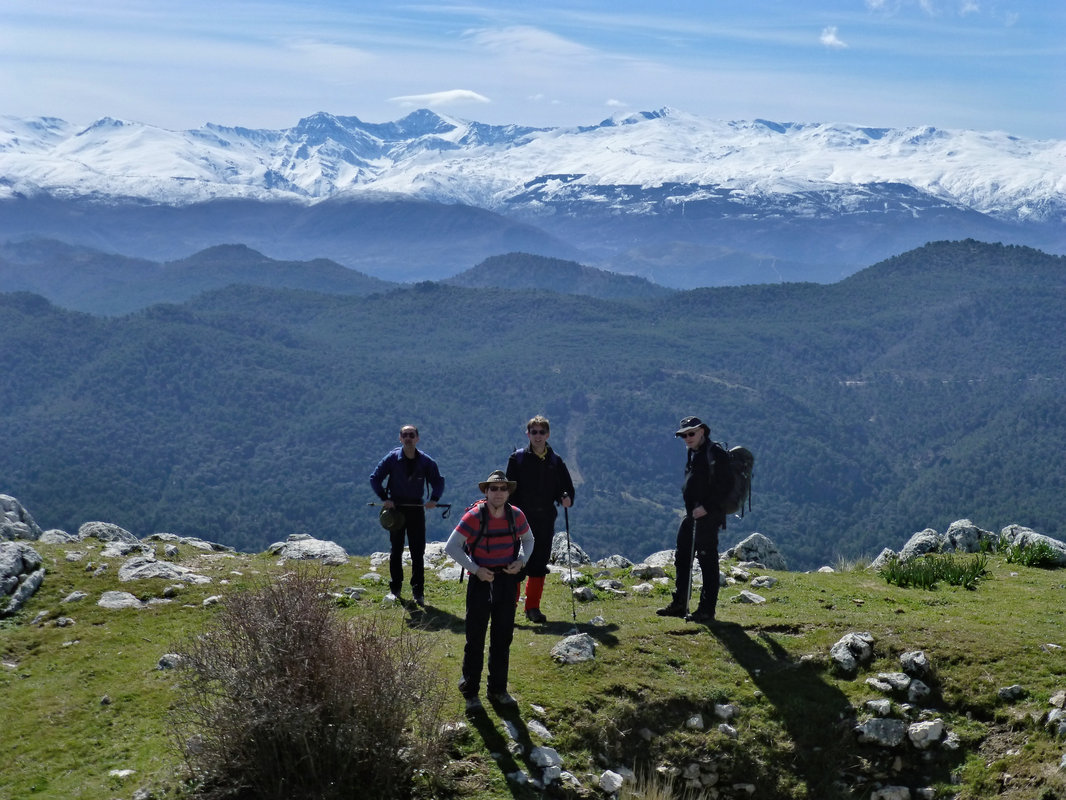
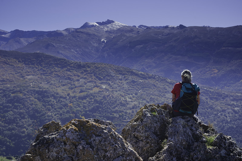
8. Collado del Aguacil – Pico del Jinestral (Sierra Nevada) (45–50 min from Granada)
- Highlights: High mountain landscapes, panoramic Sierra Nevada vistas, less-crowded trails.
- Length: 12–14 km (Circular).
- Duration: 4–6 hours.
- Difficulty: Moderate.
- Best for: Scenic views, quieter hiking, moderate challenge.
Practical Recommendations:
- Best seasons: Spring and autumn. Summer hikes should start early to avoid heat; winter hikes may require gear for colder conditions.
- Gear: Good footwear, sun protection, water, and snacks are always recommended.
- Transportation: All trails mentioned are reachable by car within an hour. Public transport limited except Monachil and Güéjar Sierra trails.
These trails provide a diverse hiking experience, suitable for everyone—from families and casual walkers to seasoned hikers looking for adventure and panoramic mountain vistas.
Details of our Granada Hikes
Camino Mozarabe
Leisurely
| Distance: | 12 km |
| Ascent: | 356 m |
| Time: | 4 hrs |
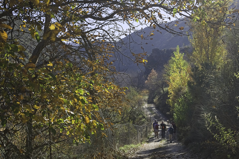
The Camino Mozárabe is a historic pilgrimage route that connects the southeastern regions of Spain to Santiago de Compostela. The segment from Dúdar to Granada is a picturesque portion of the Camino Mozárabe, offering pilgrims a blend of natural beauty and cultural landmarks.
Why Choose Camino Mozárabe near Granada? Cultural Richness: Offers a deeper understanding of Andalusia’s complex history through tangible cultural heritage. Authenticity: Less crowded compared to other popular Camino routes, allowing for reflection and genuine interaction with locals. Natural Beauty: Stunning landscapes featuring olive groves, mountains, and traditional villages.
Sierra Elvira
Moderate
| Distance: | 8 km |
| Ascent: | 435 m |
| Time: | 4 hrs |
The Sierra Elvira is a compact but picturesque mountain range located just 10 kilometers northwest of Granada, in Andalusia, Spain. Known for its geological significance, archaeological history, and panoramic views, it's a popular area for hiking, trail running, climbing, and nature exploration.
Outstanding vistas of Granada, the vast plain (Vega de Granada), Sierra Nevada, and nearby hills. Full of interest with Roman remains, medieval fortifications, prehistoric cave dwellings, and the Ermita de los Tres Juanes chapel.
Near the summit of the Sierra Elvira, specifically close to the peak Morrón de la Punta, there's a notable geological feature — a fissure or fracture commonly referred to locally as the Raja de la Sierra Elvira. Although frequently described as a volcanic fissure, Sierra Elvira itself isn't volcanic in the classic sense. Instead, it consists primarily of limestone and dolomite rocks from the Jurassic period. The fissure is essentially a tectonic fracture rather than volcanic activity from recent geological history.
Tajos de los Bermejales
Moderate
| Distance: | 12 km |
| Ascent: | 257 m |
| Time: | 5 hrs |
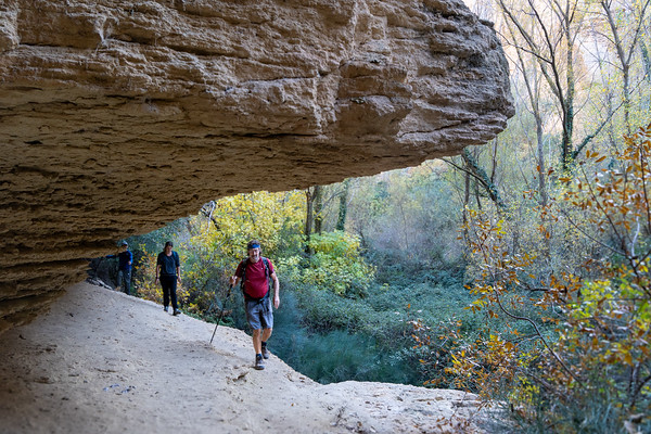
The Tajos de los Bermejales Trail (Ruta de los Tajos de los Bermejales) is a scenic hiking route located in the vicinity of Embalse de los Bermejales, about 45 minutes southwest of Granada, Spain, near the village of Arenas del Rey
This hike is renowned for its impressive geological formations, stunning views of dramatic cliffs (tajos), lush vegetation, and clear turquoise waters of the Bermejales reservoir.
The trail descends to the Cacín River, leading hikers through the Tajos de los Bermejales gorge. The path includes multiple river crossings facilitated by wooden bridges, sections equipped with ropes and ladders, and scenic views of the canyon's steep walls. Hikers will encounter features such as hanging bridges, ladders, and support ropes to aid in navigation.
Alto Calar & Miguelejos, Güéjar-Sierra
Moderate
| Distance: | 10 km |
| Ascent: | 539 m |
| Time: | 5 hrs |
A hike starting from Collado del Aguacil (also known as Puerto del Collado del Agua or Collado del Alguacil) is a beautiful and less-crowded option in the Sierra Nevada National Park, offering spectacular views, varied landscapes, and a range of trails suitable for moderate to experienced hikers.
This hike visits Alto del Calar and Alto de Miguelejos near Güéjar Sierra offers an enriching experience of the Sierra Nevada's northern landscapes. This circular route provides hikers with panoramic vistas, historical landmarks, and diverse terrains
Monachil Gorge
Moderate
| Distance: | 10 km |
| Ascent: | 350 m |
| Time: | 4 hrs |
Hiking the Monachil Gorge (also known as the Los Cahorros de Monachil) is one of the most popular and scenic hikes near Granada, offering a thrilling adventure through a narrow canyon, along hanging bridges, waterfalls, and carved rock passages. It’s a great mix of natural beauty and light adrenaline.
There are several suspension bridges, some quite long and exciting, crossing the gorge above the river, offering spectacular views. Safe but thrilling—especially popular with children. Certain areas require walking through narrow passages carved by the river. Occasionally you’ll need to crouch, climb ladders or handles set into rock walls—adds to the adventurous feel of the hike. There are crystal-clear streams, small waterfalls and pools ideal for cooling down on hot days.
Ruta Gollinzo, Moclin
Moderate
| Distance: | 8 km |
| Ascent: | 539 m |
| Time: | 5 hrs |
The Ruta del Gollizno, located in the municipality of Moclín in the province of Granada, Spain, is a captivating circular hiking trail that combines natural beauty with historical significance. This route offers hikers the opportunity to traverse scenic landscapes, cross suspension bridges, explore river gorges, and encounter ancient cultural landmarks.
The trail passes through breathtaking terrain, including steep canyons, lush river valleys, dramatic cliffs, waterfalls, caves, and panoramic views of the surrounding olive groves and mountains. Stunning viewpoints offer beautiful vistas of the medieval fortress of Moclín, the village itself, and the entire Granada countryside.
The Ruta del Gollizno features exciting hanging bridges (puentes colgantes) crossing the Gollizno gorge. These bridges are a major attraction, adding adventure and excitement to the hike. Metal walkways attached to the canyon walls lead you through narrow and beautiful sections of the gorge, making the route feel adventurous and unique.
Moclín is a historically significant village dominated by the impressive Moclín Castle (Castillo de Moclín), which was a crucial Moorish fortress during the Reconquista period. The route passes near ancient cave paintings at the Cuevas de Malalmuerzo, dating back to prehistoric times, offering hikers an opportunity to connect with the area's deep historical roots. The trail runs along the Río Velillos, a small river that creates picturesque waterfalls and crystal-clear pools, especially beautiful after rain or in spring. Excellent spot for photography, relaxation, or a refreshing break on hotter days.
Barranco Tintin, Quentar
Moderate
| Distance: | 12 km |
| Ascent: | 385 m |
| Time: | 4 hrs |
From the reservoir, the trail ascends gently, passing beneath a statue of a mountain goat. This section leads to the highest point of the hike at approximately 1,405 meters along the Cuerda de Hazas Negras. After reaching the peak, the path descends into the Barranco del Tintín. This ravine is characterized by its natural beauty and offers hikers a serene environment as they follow the Tintín stream back toward the starting point
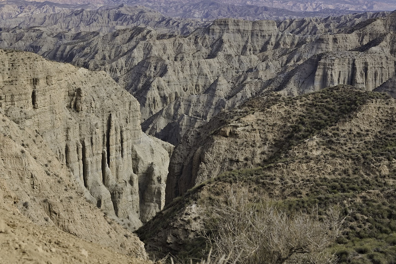
Desierto de Gorafe
Moderate
| Distance: | 14 km |
| Ascent: | 284 m |
| Time: | 5 hrs |
This circular trail guides hikers through the heart of the Gorafe Desert, showcasing its unique geological features and expansive views.
The Gorafe Desert is renowned for its badlands, featuring eroded landscapes with canyons, ravines, and unique rock formations. The area boasts one of Europe's most significant concentrations of dolmens, with over 240 megalithic tombs spread across the landscape, offering a glimpse into ancient human history.
Dates & Prices
When?
Prices
Group size (per booking) (prices are per person per day)- 1 person - cost €110
- 2 persons - cost €75
- 3 persons - cost €65
- 4 persons - cost €55
Definition of "Group" - if you are booking a trip for 2 persons the 2 person rate applies, 3 persons - 3 person rate etc (not dependent on eventual total group size!).
Price includes:- Guiding (Alpujarras, Granada area, Lecrin Valley, Costa del Sol, Granada
- We have a limited number of walking poles for the use of guests if required
N.B Meeting place to be agreed upon, normally Lanjaron or the start of the walk
Larger groups - discounts apply. Enquire via email or contact form
Transport (effective for all bookings after 1st July 2022)
The guiding price above does not include transport. Due to rising energy and fuel prices we do not want to be constantly changing guiding prices to reflect transport costs. We want to be honest and open about our price structure.
Clients have two options:
NO COST OPTION - Pick up/drop off our guide in Lanjaron or a venue to be agreed. Use your own transport to and from the start/end of activity.
COST OF FUEL OPTION - Our guide will drive you to/from start/end of activity in one our own vehicles. Applicable costs are:
- Capileira, White Villages, Taha del Pitres €25
- Hoya del Portillo €35
- Sierra Nevada ski area €35
- Granada area, Cumbres Verdes €20
- Peñon de la Mata €25
- Lecrin Valley €15
- Jerez de Marquesado, Eastern Sierra Nevada €60
N.B For destinations not listed above we can easily work out a fuel cost
You may also be interested in?
Day walks in the Cumbres Verdes mountains near Granada
Various guided day mountain walks of all grades visiting the beautiful and varied Cumbres Verdes range just south of Granada
Day Walking Tours to mountain lakes of the high Sierra Nevada, Spain
Escape the heat! Join us for day and multi-day hiking trips to visit the beautiful, quiet summer mountain lakes of the Sierra Nevada
Guided Day Walks Tabernas desert badlands, Almeria
Amazing guided day walking tour in the incredible desert badland landscapes of Tabernas, Almeria, visiting scenes from major movies and spaghetti westerns
Join Chris Stewart Walking Weeks in the Alpujarras, Spain
We have teamed up with writer Chris Stewart and delightful accommodation at Casa Ana for you to enjoy a weeks guided walking holiday in the Alpujarras
Climb the high peaks of the Sierra Nevada in Spain with us
Guided day or multi-day summer or winter mountain ascents of the high peaks of the Sierra Nevada