Report from a trek a few days ago in the Sierra Nevada
Access to the trek
We left our cars at the Hoya de la Mora at 2500m above the Sierra Nevada ski town. From there a bus takes you up to 3100m at Los Posiciones which saves the legs a couple of hours of uphill effort. At Los Posiciones, watch the hordes making their way towards Veleta and then turn opposite! Head north along the upper part of the Tajos del Campanario ridge. All along the journey north the cliff of the Tajos del Campanario have been looming on the right. Ahead, some 50m is a metal cross/sign of some sort. Turn right here and descend 10 metres. The start of the path is marked by a large cairn. This is the start of the Veredon Inferior

Descending from Los Posiciones to the start of the Veredon Inferior
The most spectacular path in the Sierra Nevada that nobody knows about!
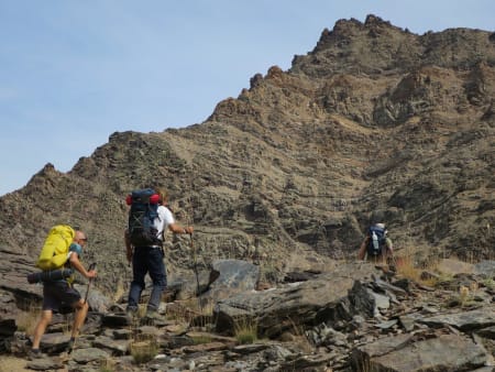
The Veredon Inferior is definitely superior to the better known "Veredon Superior" that leads into the Corral del Veleta some 500m south. It deserves to be known as the most spectacular path in the Sierra Nevada that nobody knows about! We now head down onto a "vasar", a descending rake which rather cleverly circumvents the vertical cliffs above and below.

The spectacular Veredon Inferior
And, this is so spectacular. Yes, there are some places where the nervous might need to gird their loins and press on. There are a couple of narrow sections where the exposure might threaten. But, in the main it's just a glorious high level mountain track. Ahead lies the northern cliffs of Veleta itself and to the left the valley of the Guarnon, into which we are descending.

Yes, it's as steep as it looks!
All too soon we reach the valley floor. This now has to be crossed. There are indictions of a path but to the east can be seen the steep zig zag track leading to Veta Grande, our next objective.
The Northern Flanks
We have now to cross the Guarnon valley and rise up to Veta Grande. Signs of a path begin to materialise and then we have the steep rise to the Collado de Veta Grande. This is the hardest section of the first day due to the steepness and looseness of the terrain. As a reward the Collado is an impressive place to be. Rising above is Cerro de los Machos and to the east Mulhacen, Alcazaba and Puntal de la Caldera command the eye.

At the Collado de Veta Grande

Laguna Larga and Puntal de la Caldera
The route ahead can now clearly be seen, cross the valley of the Rio Valdeinfierno and then contour round to reach the lakes at Laguna Galbata and Laguna Larga at the head of the Rio Valdecasillas.

Looking east to Juego de Bolos and Alcazaba
This path initially traverses between crags and then becomes undulating until the lakes are met.

Looking down to Laguna Galbata and Laguna Larga
Laguna Galbata and Laguna Larga
These relatively unknown lakes perch below the mighty northern crags of the Puntal de la Caldera and Loma Pelada. Few venture here, only those lucky few who prefer isolation and wish to getaway from the hordes heading to Mulhacen along the old road higher up!

Camp site Laguna Galbata, surrounded by cliffs
Pick your camping spot. There are plenty. We preferred to site our camp about 50 metres south west from Laguna Galbata. here, we are well away from the lake and also would cause no damage to the fragile green "borreguiles" environments. Our camp site even had a prebuilt table and chairs!

Watching the sunset over Laguna Galbata
Overnight the wind built up and there were some strong gusts. It was also probably the warmest night I've ever spent above 2800m.
The Early Morning Start
There's something special about striking campsite pre dawn and hiking in the first daylight hours, whilst the rest of the world is seemingly still in bed. The sunlight soon hits the mountain tops and a myriad of colours adorns the summit rocks. You amble slowly along the deserted mountain tracks. You are alone in the still and quiet of the hills sharing the experience with animals and birds.
In the summer Sierra Nevada, any bad weather is likely to arrive mid afternoon. Of course, by then, we are enjoying a few cold beers and reflecting on unforgettable shared mountain moments.
My advice? Try it. Start early, finish early.

Early morning start
We contoured round the northern side of Puntal de la Caldera and climbed up a shallow valley south west of the strangely named peak of Juego de Bolos (3021m). At a small col we admired the north face of Mulhacen as the suns rays finally reached us.

Approaching the col near Juego de Bolos
From the col south of the summit some of us took to an entertaining scrambling route up a shallow ridge before we traversed up to the Col del Ciervo and well known territory.

Scrambling on the ridges near Juego de Bolos
The Return Journey
We had met nobody for a day and a half. At the Refugio de la Caldera we saw people in the distance heading for Mulhacen.We turned west and took the rising traverse behind the refuge leading to Loma Pelada (also known as Puntal de Laguna Larga). Here we sheltered from the gusty winds in the lee of the summit.

The Rio Crestones ridge with Alcazaba behind
We followed the old road, taking the photo opportunity of Collado de los Lobos and then finishing via the Paso de los Guias before arriving at the Col de Carihuela. We knew there was a return bus leaving around 13:15 so quickly made the 30 minute journey to the bus stop at Los Posiciones.

The impressive Collado de los Lobos

Traversing the, chain enabled, Paso de los Guias
Summary
This isn't in itself a long trek. Only 15km. But this took us 9 hours to complete and it's full of interest. It should not be rushed, it's too good. Take your time, enjoy the narrow tracks and exposure. Marvel in the intricate way the path finds ways through seeming impasses. Above all, take in the isolation and dramatic surrounding of a part of the Sierra Nevada few get to see.

Traversing below Puntal de la Caldera