The Cumbres Verdes just SE of Granada offers so much good walking especially for those with an exploratory and adventurous nature
Since we started visiting this fascinating walking and trekking location near Granada in 1998, we have seen a rise in the popularity of peaks such as the magnificent Trevenque (2079m). However, there is so much more than the normal routes of ascent to offer for those with an exploratory and adventurous nature.
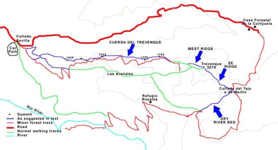
The rest of this article will make reference to our sketch map of the area below. We will try to suggest improvements to the normal routes taken on this peak. By short diversions, a better and more wonderful mountain day will be experienced.

Sketch of Trevenque area
The Cuerda del Trevenque
As can be seen, the normal route of ascent from the car park at Collado Sevilla is to follow the wide track (red) eastwards. Nice views are had, but nevertheless the going can be a bit tedious until the final ridge up to the summit is met. True, there are lovely views rightwards into the wastelands called Las Arenales (the Sands), but any view left is blocked by the Cuerda del Trevenue. A much better route is to follow the Cuerda directly.
There is a faint track and the views northwards towards the Cerro Huenes group are great. Even better, one has the magnificent and usually snow covered Sierra Nevada range as a spectacular backdrop to the walk ahead. The range spreads from the Cerro de Caballo right through to the second highest peak, Veleta (3398m). Sure the ridge has a few ups and downs, but the track is relatively easy and no scrambling is involved. The photo below shows the Cuerda crest. The normal route can be seen lower down on the left hand side.

The Cuerda del Trevenque with access road below left
Trevenque SE Ridge
From the summit at 2079m it's difficult to find the start point if you've never been there before. The natural lie of the land takes you either back to the normal ascent route or down the E ridge. This is steep, loose, and not recommended. I know this as I've tried it! Instead look for a rightwards slanting path heading steeply downhill over loose scree.
The path steepens and crosses an mildly exposed section (interesting in powder snow conditions!) and then becomes unpleasant loose scree for a few hundred metres. There is a good path through all this however. The reward is that you have headed into an area that could only be described as "badlands". If Clint Eastwood were to ride by on the path below you wouldn't be surprised. This is the most arid part of the Cumbres Verdes and is reminiscent of the Tabernas desert in Almeria.

The steep initial descent on the Trevenque SE flank
The Dry Valley (Rambla)
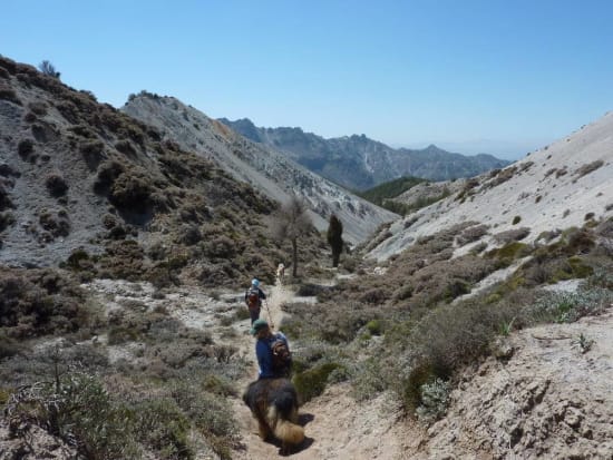
At the bottom of the SE ridge proper you will find a track heading right into a dry valley. A few mountain bikers come this way but few walkers are aware of it. The going is easy but is very very arid and dry. Little vegetation grows on the side of these small hills. This fascinating valley leads SW until it reaches a good forest road. This leads either onto Refugio Rosales and then down into the Dilar valley, or trends back towards a small pass leading to Las Arenales and the normal route back.

Coming down the dry valley. Los Alayos ridge in the distance
The Cumbres Verdes and Trevenque offer great walking and trekking destinations. The start at Collado Sevilla is only 20 minutes from the outskirts of Granada. Well worth a visit. Remember though ......... search out and enjoy those hidden gems!
