Thanks to guest writer, Ian Tupman for this report of his day walk in the Sierra Nevada peaks encircling the Rio Chico above Lanjarón, including Cerrillo Redondo and Tajos de los Machos.
The 5th to the 8th of December this year has been a "puente", a Spanish holiday celebrating both the new constitution in 1978 and the immaculate conception, several years earlier. "Puentes" usually result in large numbers of people heading for the countryside and the mountains, especially when the weather is good. On these occasions I try to seek out the quieter, less travelled routes and so with light winds and sunshine forecast for the day, I decided on a high level walk around the Río Chico valley.
I hadn't been above 2,000 metres since June of this year and so I was anticipating the effects of altitude and my lack of hill fitness. My border collie, Meg accompanied me and we set off from the Puente Palo recreation area at just before 10.00 am. The forest track winds its way up the west side of the valley and has a relatively gentle gradient. The only sounds were from the numerous birds twittering in the sunshine - it was one of those 'good to be alive' mornings. We exited the forest at around 2,300 metres and continued to the large animal shed marking the point at which we headed north-west to commence the steep ascent to the ridge line.

Animal shed and the Sierra de Lujar
Away from the shade and cool of the forest, the sun and warm air did nothing to assist my efforts. There is no path as such and it's a case of taking the most efficient route to arrive at the ridge as high as possible.
Now this is where it gets confusing. Depending on which map you have, the first summit is either un-named (Editorial Penebetica) or is called Cerrillo Redondo (Editorial Alpina). Why confusing? Because two kilometres further along the ridge is another Cerrillo Redondo which is shown on both maps. The Editorial Piolet (La Integral De Los 3000) also shows two Cerrillo Redondos, so let's just accept that cartographers can be a fickle bunch.
The ridge is broad and rocky but gives superb views. To the west, Cerro del Caballo is the highest 3,000 metre peak in western Europe and in the distance, the peaks of the Sierras de Tejeda, Almijara and Alhama were visible above the cloud.
To the east, the Loma del Cebollar and its refuge were bathed in sunshine and far away to the south-east, the Sierra de Gador rose above the cloud.

Cerro de Caballo
The chilly west wind hastened our progress along the ridge until we arrived at Cerrillo Redondo (No.2), which at 3,055 metres, makes it a Tres Miles. Sheltering in the lee of the summit rocks, Meg had a late breakfast and I started into my packed lunch. Moving on, we dropped down slightly before the gentle ascent to Pico del Tajo de los Machos (3,085 metres), our second Tres Miles. Here we met a Spanish couple with their young German Shepherd dog. They had stayed in the Caballo refuge the night before and were heading to the Cebollar refuge for the night before walking down into Lanjarón in the morning. We chatted as we walked together down the south-east ridge to the col and I was able to show them the feint route across the west flank of the Loma del Cebollar which took us directly to the refuge.
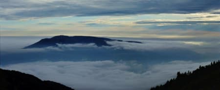
After a bite to eat and a drink from the fuente, we said "Adios" and headed steeply down to the Río Chico. There was less water than usual but enough for Meg to have a paddle before we continued along the west side of the valley. To the south, the morning's cloud inversion had deepened to form a thick blanket, filling the valleys below us.

The Sierra de Lujar: An Island In The Clouds
Continuing on the good path, we eventually joined our outward route in the forest and walked back down to the car. We had covered 20 kilometres in just under six hours, clocking up 1,400 metres of ascent. And all of it above cloud level. A great day out!
Ian Tupman December 2015