Yvonne Holland's report of May 2012 trek in the Sierra Nevada covering all the major peaks including the rarely climbed Juego de Bolos and Puntal de la Caldera
Full and interesting report from guest writer, Yvonne Holland, who returned to the Sierra Nevada in May 2012 to do a trek from Trevélez to Lanjarón, covering all the major peaks of the Sierra Nevada between the two villages, including the rarely climbed Juego de Bolos and Puntal de la Caldera.
In early June 2008 I attempted a traverse of the Tres Mil ‘integral’ of the Sierra Nevada from east to west .There had been a huge dump of snow the week before we arrived and the conditions made progress slow. That, combined with very bad visibility on the fifth day meant that we had to effectively bypass the last two interesting sections of the traverse. Although we had succeeded in traversing the massif, there was unfinished business and I promised myself a return trip in the near future.
Life has a habit of racing ahead and before I knew, four years had elapsed before the moment presented itself for a return visit. This trip was planned to begin on 12th May in a year when there had been virtually no winter conditions. That is until about three weeks before our arrival when, looking at the weather forecast daily, it seemed to be snowing continually for a couple of weeks. Just prior to departure I checked with Richard from Spanish Highs – yes, the mountains were indeed in winter condition. The good news was that the weather looked perfect for the duration of our visit.

Summit of Mulhacen looking to Veleta
}We got a lift to Trevelez early Sunday morning, but by the time we had found the trail head for the south ridge of Mulhacen, time was getting on and it was hot. Unlike other more popular mountain areas of Europe, there are almost no trail signs and the locals don’t seem to have a clue as to where the trails start. We were told it was too far to Mulhacen and we should try a different approach!! So we were dropped off on a dirt track, and after a frustrating hour of trying to relate everything to the map, we managed to locate the trail. I had similar problems trying to find the trail last time when we left Jerez – getting out of the valley in the Sierra Nevada isn’t easy.
We were carrying food for four nights out in the mountains, as well as crampons, lightweight ice axes and a small amount of climbing gear. This time I had decided to use the refuges rather than camp – mainly because of the problem with foxes on my previous trip, when my tent had been raided on the last night. Not an experience I was anxious to repeat.

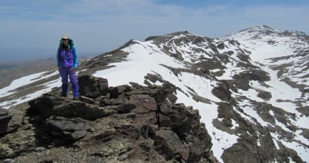
Alcazaba from Puntal de la Caldera
}In spite of the heavy-ish loads, once we were on the way I was enjoying myself; setting off on a high mountain traverse with everything I needed on my back. The ascent to the ridge was steep, and it was a particularly hot day. Andy was finding the going tough and we were not making the progress I had intended. At about 5pm we had reached the ridge and it was obvious that we weren’t going to traverse Mulhacen that night – with about 900m of ascent still to go. There was the option to drop down to the Poqueira refuge but this was a loss of valuable height and meant we probably would miss out Mulhacen the next day. I suddenly had the idea that with the few snow patches around we may be able to find a good bivvy spot. Within minutes we had found a re-entrant with a substantial snow bank that made a stream of running water. We quickly established ourselves for the evening, enjoying the last heat of the day. As we settled down in our bags, there were a few spots of rain from a threatening, black cloud; fortunately it came to nothing and we enjoyed a peaceful fox-free night.

Leaving the Refugio de la Caldera
}We were away at 8am the next day, gradually gaining height on the south ridge and arriving on the summit before the hordes from the Poqueira refuge. The summit was every bit as impressive as I remembered, cliffs plunging steeply down on the snow covered north face. We took the obligatory photos from the exposed summit rocks and as others started to arrive we began the steep descent to the Refugio de Caldera which is nestled beneath the Puntal de la Caldera. This small 3000m summit looks really impressive and is graded PD in winter conditions. I left Andy at the refuge and climbed the steep but softening snow slopes to a col on the ridge, just before the final summit step. The summit ridge was narrow and airy; care was needed in the strong wind that had blown up during the afternoon. I dropped back down the ridge to a point where I could descend on the north side to the connecting ridge of the outlying Pico del Juego de Bolos. The snow was soft but I was soon on the summit, enjoying the magnificent views of the north faces of Alcazaba and Mulhacen. The wind was strengthening by the minute as I retraced my steps and then followed a traversing line which took me to the Collada de Ciervo and back to the refuge.
We spent a pleasant evening chatting to the only other occupant – a guy from Belgium who had trekked and climbed in most of the same parts of the world as me. It’s good to meet like minded people in the mountains and we enjoyed sharing stories of other mountain adventures and dreams.

Outside the Refugio Cariguela
}The wind blew strongly all night, rattling the door and generally making a lot of noise. I didn’t sleep well and the cold I had been fighting off seemed to reassert itself. It was my turn to feel washed out and tired as we made the easy walk to the Refugio de la Cariguela, taking in the summits of Cerro de Los Machos along the way. The ascent was mainly on good snow and the summit also has really impressive cliffs on the north side. Although there wasn’t as much snow on the Sierra Nevada road as last time, it was still completely banked out near the refuge and the going was hard. We also struggled to find water until early afternoon when the snow melt made small streams and even waterfalls down some of the steep cliffs above the Sierra Nevada road. I was relieved to arrive at the refuge at 2pm and spend the afternoon resting, trying to regain my strength.

On the Tajos de la Virgen Ridge
}The following day we were planning to traverse the Tajos de la Virgen, one of the more technical sections of ridge on the traverse of the Sierra Nevada. Although the difficulties are not great, there is some exposed scrambling to bypass the steep steps in the ridge and there was also a fair amount of snow. I was a little concerned that we weren’t moving fast enough and with my state of ill health was not too enthusiastic. However, the hand of fate intervened in the form of two lovely Spanish guys, Tomas and Pascual, who arrived at the refuge soon after us. I took the opportunity to practice my Spanish and it was soon established that they were doing the ridge the next day and we would all go together. I explained that we may be a bit slow but was told it would take two hours maximum!!
I felt a lot better the next morning, the wind had dropped and we had a relaxed breakfast before setting off for what was a fantastic traverse. We were mostly on snow which that was at just the right consistency to move confidently without crampons. The difficulties were interesting but never excessive. Care was needed on the exposed slabs of the first traverse and the steep snow of the second. But sure enough, in two hours we were at the ruined Refugio Elorrieta. After lots of hugging, photos and exchange of email addresses, the Spanish set off on the next section to the Pico Del Cartujo. We followed at a more leisurely pace and traversed the Tajos Altos to the Cerro de Caballo, the most easterly of the 3000m summits.

Bivouac by Laguna de Caballo
}We descended to the Laguna de Caballo intending to spend the night in the refuge. We found it to be quite damp with a few puddles on the floor. As it was such a lovely evening and an idyllic place we opted to bivvy by the lake. The sun was hot for a couple of hours so we relaxed and enjoyed our last afternoon and evening in these wonderful mountains. The cirque was still full of snow and the lake covered in ice which creaked and groaned like a glacier. I was thinking what a great place this would be to spend some time in real winter conditions – the next trip!
The walk down to Lanjaron the next day was both pleasant and gruelling. The early morning was very enjoyable, high on the ridge above the valley in the cool of the day. When we reached the dirt road the path didn’t follow the steep descent to the valley shown on the map. It appears there is a new path, well marked with stones, which gradually zigzags down to the bridge across the river. The day got hotter, the packs seemed heavier and it was with much relief that we eventually arrived back in civilization. But the profusion of flowers was magnificent, becoming more colourful and abundant the more we descended. Arriving at the far end of Lanjaron, we walked the last kilometre through the town to our hotel and somehow found the energy to get clean and go out to celebrate the trip. Tired as we were, it was a delight to indulge in pizza and beer rather than ‘Mountain House’ meals and oatcakes. There are some pleasures of being in civilization, especially in Spain.

Ridge to Tajos Altos
}It had been a fantastic five days, maybe not as intense as my first trip but I climbed all the peaks I hadn’t been able to do last time. The Sierra Nevada is not an extensive range and with the road at 3000m it would appear to have been ‘tamed’. But this belies a wildness which is comparable or even more than that found in a lot of mountain areas in Europe. There are very few signed or way marked trails in the Sierra Nevada, the paths are not well trodden and the mountain routes are rough. There are many interesting and more technical routes to suit all levels of ability, there is a good network of basic but functional mountain refuges and there are very few people at the times when the conditions are good for mountaineering. Although I’d say I’m now quite familiar with the area there are still many valley approaches, peaks and scrambles to explore as well as the real winter mountaineering potential. I’ll definitely return, the area has worked its magic and is now amongst my favourite mountain destinations.
For info - Mountain huts and refuges in the Sierra Nevada and Self Guided Trekking Support in the Sierra Nevada.