From the west of the Sierras and the Vega of Granada Tajos Altos is just a small lump on a long, seemingly flat ridge. From the north and south it is prominent, but often mistaken for Veleta, the Pico del Cartujo or some other more well known peak. But it is in fact a superb mountain in it's own right.
Depending on which map you use Tajos Altos can be difficult to identify. Sometimes it is just a series of high points on the long ridge running from Pico del Cartujo to the Cerro de Caballo. Sometimes it is marked as a particular point, incorrectly in my opinion! The Tajos Altos I know and love is the prominent "mountain" looking mountain (if you understand what I mean?). From the north and south it is a pyramid. A classic mountain shape. The sort kids draw at school.

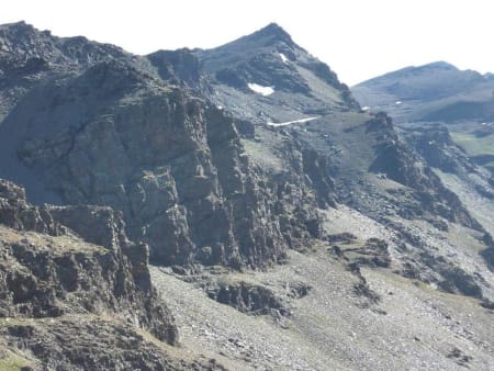
Tajos Altos east face dropping down to Laguna de Bolanos
So where is it? From the Pico del Cartujo heading south you will pass over two smaller lumps before meeting the rise up to what I call "Tajos Altos". On the Penebetica map series for the Sierra Nevada, this is shown as point 3104m. This is the summit. Not the series of lower points further south that the map shows as "Tajos Altos", nor any of the smaller inconsequential lumps going north.
It's relatively gentle slopes dropping down west from the summit are marked as Los Panderones. Rather boring terrain in summer, but superb country for ski tourers during the winter, if approaching from Fuente Fria above Niguelas.
It is to the east however where the dramatic beauty of this mountain is seen at it's best. Steep cliffs drop sharply to ledges containing probably the finest mountain lakes in the Sierra Nevada, namely Laguna Cuadrada and Laguna de Bolanos. Tranquil places to stay for a night in the mountains. There is a steep scree slope running east some 100m south of the summit. This can provide access from the summit ridge to the lakes.

Laguna Cuadrada and an idyllic campsite location
An ingenious path, the Verea Cortada cuts across this ledge on it's way from the Cerro de Caballo to the Laguna de Lanjarón and the Refugio Elorrieta. In fact, some 200m north of Laguna Cuadrada, there is a short section of path where use of a cable/chain is required to cross a short rock gully.
Below this narrow ledge the cliffs tumble down to the lush green pastures of the upper Rio Lanjarón valley. A real shangri-La, especially in the fierce heat of summer.
Tajos Altos is a real mountain and deserves to be known as such. I for one will be back in the winter to try out some of the winter possibilities on the east face.
If you wish more information on Tajos Altos, access, trails etc please contact me. We run two day crossings of the Sierra Nevada that stay at Laguna Cuadrada overnight. These run throughout the snow free months, namely June to November inclusive.

The prominent peak of Tajos Altos from the Refugio de Caballo