Trip report in the Sierra Nevada from 2nd to 7th August 2017
Words and photos courtesy of Jennifer Stott
Day 1 – Day of most ascent (1,730 metres)
I set off from LOMA DE LOS CUARTOS. Immediately I was feeling the heat and altitude, which was making my 12Kg bag feel a lot heavier! I headed East (away from my final destination), to extend the suggested route. I walked off the path, and down into 3x valleys, where I stopped to dip my already hot feet in a stream. By sunset, I arrived at the summit of PENON DEL MUERTO II (apparently an infrequently visited mountain), where I bivvied inside of the cairn. I witnessed some impressive shooting stars (leading up to the Perseid meteor shower, due to peak just over a week later), and slept under the light of the nearly full moon.

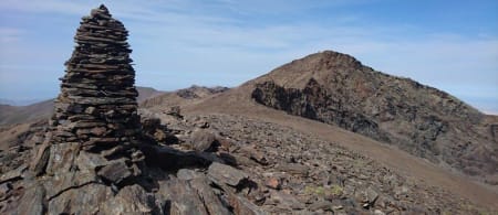
Summit of Picón de Jérez
Day 2 – I saw a Snake!!
I awoke to an interrupted view of a beautiful sunrise, and distant mist in the valley. I attempted to reach the rock formations at the adjoining PENON DEL MUERTO I, but it was surrounded by 100s of goats, and accompanying guard dogs who did not wish me to pass. I passed horses/cows/lizards, whilst walking down into 2x valleys, finally enjoying my breakfast by the RIO CHICO. My original plan of climbing directly up the other side of the valley was prohibited (yet again) by 100s of goats! I instead followed the RIO GRANDE, which must have been fate, because I was very excited (and a bit scared) to see a snake! (later identified as a ‘Smooth Snake’ which is very rare in this area). After re-filling my water pouches, I calculated that despite carrying 3.5 Litres, it was necessary for me to head back West – otherwise I would run out before reaching any more streams/lagoons. This was my longest mileage day, totalling 15.9 miles hiked. After a long ridge walk, I took a very steep descent down to LAGUNA DE JUNTILLAS, and set up camp on the little island.

Looking down to the lake from Puntal de Juntillas
Day 3 – The Scrambling begins
The terrain from this point became rocky, and I was happy to see my first Ibex of the trip. After COLLADO DE VACARES, the Scrambling began (I followed the rocks to the right, which looked more enticing). Although I had not intended to follow this path, I headed down to LAGUNA DEL GOTERON to collect water. This added an extra hill onto my route, to get back onto the ridge – but it was I an enjoyable one. I then took an interesting short cut, towards the foot of ALCAZABA, down through the TAJOS DE GOTERON valley (as recommended by the guide). I passed a plane wreck, and then came across a series of ice-cold streams, leading to a massive waterfall (not shown on the map), flowing over an impressive cliff edge, down into the valley below. I had intended to bivvy on ALCAZABA (the 3rd highest mountain the Sierra Nevada, at 3,371 metres), but the cairn (i.e. the only flat location) was already taken by 3x Spanish wild campers. After a friendly chat with them, and a few photos, I bivvied a little further down the ridge, by a shelter, which I had scoped out on the way up (just in case). This was the perfect spot to see the both the incredible sunset and sunrise, with no mountains blocking my view.

Ridge to Puntal de las Calderetas with Alcazaba behind
Day 4 - The scariest day of the trip!
I moved to the peak at the head of the SIETE LAGUNAS valley, to enjoy my breakfast with a view. After determining that direct access to PUNTAL DE LA CORNISA would be disastrous, I headed partly down the path into the valley, and then scrambled back up to the slabs instead. LAGUNA ALTERA and the other nearby Lagoon was dried up, so I descended further down into the valley to access water. I returned to the ridge, up to PUNTAL DE SIETE LAGUNAS (where, despite the heat - I saw snow!) Here I prepared myself for the exhilarating traverse across TAJOS DE MULHACEN (as suggested by the guide). Approximately 1.1 miles of narrow trail, with a 200 meter vertical drop to the right, and the mighty MULHACEN (i.e. no escape) to the left…This route is definitely not for the faint-hearted! One particularly heart-racing section was a large rock, which I had to climb down down…with a chute-like vertical drop situated directly below it! One nice surprise, however, was the ice-cold watercourse flowing from within the rock. I summited MULHACEN (the highest peak in the Sierra Nevada, at 3,482 metres), which was crowded, and even being accessed by horse! I discovered afterwards that I had visited this peak on the one day of the year where the road is opened up to just 3 miles away from the summit – making it easily accessible by all…typical! The proper scrambling began at PUNTAL DE LA CALDERA, which was definitely challenging for me, as a solo scrambler in unfamiliar territory. I encountered 3x petrifying (but highly satisfying) moments;
- Crawling across a ledge with a drop at either side (I learned later that this was avoidable)
- Shuffling down a steep scree slope, with a vertical drop below, with only a wobbly rock to climb across, to reach safe terrain (also apparently avoidable!)
- Unable to safely climb down a ledge, I threw my rucksack down below, ahead of me…which lead to a big gash in both my rucksack, and a 1 Litre water pouch stored inside! (and was still a struggle for me to descend)
With these challenges, this was my slowest moving day, at 0.8mph. After a mentally and physically tiring day, I decided to skip the final 2x scrambles, and set up camp at the large blue shimmering LEGUNA DE RIO SECO. I enjoyed my favourite camping meal of the week (dehydrated beef and bean stew with instant mashed potato), and set to work repairing my gear.

Summit of Mulhacen
Day 5 – Hola!
After a short stroll along a cycle track, I summited CERRO DE LOS MACNOS, via a rocky short-cut, as suggested by the guide. This was an unexpected pleasure…the climb, summit, and impressive views. I came across a little Via Ferrata at VASARES DE DEL VELETA, where I had my first successful conversation in Spanish (which I had been teaching myself ‘en-ruta’). After wading past the hordes of hikers/marathon runners/cyclists to summit VELETA (the 3rd highest mountain the Sierra Nevada, at 3,394 metres), I was rewarded with a relaxing Iridescent (rainbow) cloud. The TAJOS DE LA VIRGEN offered some very enjoyable scrambling indeed, with plenty of cairns along the way, to lead me in the right (i.e. safe) direction. I saw several Griffon Vultures circling the area (as well as some boney evidence of their previous meals!) With 7x summits along this ridge, this was my most summited day, totalling 17x peaks. I explored the very interesting ruins of REFUGIO FORESTAL ELORRIETA MAJ ESTADO, hidden away underground. The Ibex, however, kept sneaking into the other tunnels – and we kept scaring the life out of each other! With the wind picking up, I headed to REFUGIO DEL CABALLO, which I happy to have to myself. I kept the door open, so that I could keep an eye on the full moon, and listen to the rocks fall, as the Ibex moved around outside. I made myself a hot chocolate, lit some candles, put a heat pack in my sleeping bag (for extra cosiness), got out my book…and felt positively calm (despite the gale blowing outside)

Summit of Cerro de los Machos looking towards Veleta
Day 6 – Refuge life
After my best night’s sleep of the week, I woke to watch the sunrise, and sat on my little doorstep, feeling content. I drank Earl Grey tea and sat admiring the views - for over an hour. One very brave Ibex joined me, and I eventually had her eating food from my hand….After stalking them all week, finally they come to me! I had a whole herd of females outside of the hut, with their little ‘el nino’s in tow. In that moment, I felt like I was truly at home. I was sad that this was my last day in the mountains, and I did not want to leave – but I was also excited to tell everybody about the challenges that I had overcome. As my first solo trip abroad, this was certainly an achievement, and Sierra Nevada is definitely I place where I will return.

A small and very unafraid Cabra Montes at the Refugio de Caballo
Trip Statistics
- 69.7 miles
- 70 summits
- 6,706 metres of ascent
- 1.24mph average speed
More photos below

First night bivvy, Penon del Muerto II
 Smooth Snake at 2450m")
The rare (for the Sierra Nevada) Smooth Snake at 2450m

Sunrise from Peñon del Muerto II

Back on the ridgeline early morning

Camp Lagunas de Juntillas

Improvised bivvy near Puntal de Goteron

The line of the Vasar de Mulhacen clearly seen from near Juego de Bolos

The ridge of the Puntal de la Caldera

Evening meal!

Camp at the upper Rio Seco

Paso de las Guias

The Refugio de Caballo

Jennifer Stott outside the Refugio de Caballo