Many thanks to guest writer Ian Tupman for this report and photos from a visit to a relatively unknown but wild and remote area of the Sierra Nevada
In September 2013 I paid my first visit to the Refugio Horcajo with the purpose of firstly locating it, and secondly to check its condition for possible future use. It sits at 2,200m on a small plateau between two tributaries of the Río Trevélez. In October of the same year I did a circular walk taking in some of the far north-eastern peaks of the Sierra Nevada including Cerro de Trevélez. From there, my eye had been drawn south-west along the Loma de las Albardas and the extensive ridge beyond. The maps give little information on what the ridge is like and indeed there is no path shown for all but the most southerly section. This week I decided to use the refuge as a starting point to explore the ridge.
The weather forecast for the two days was for dry, breezy conditions. The only thing I didn't know was how much snow there would be and what condition it would be in. My crampons and ice axe were already packed and I put my snowshoes in the car pending a later decision on whether to take them. Driving into the Trevélez valley, it was immediately apparent that the ridge on the east side was virtually clear of snow. I took the gamble on leaving the snowshoes in the car and I left Trevélez at 2.00 pm with Meg, our border collie. The route up the valley is a sendero local and starts just beyond the Fragua 2 hotel. It is marked with green and white stripes and the occasional wooden post.
There is a good path but in several places it turns into a stream where gravity draws water onto it.
The first half of the ascent towards the refuge is, in my view, relatively boring. Beyond the second footbridge however, the valley opens out giving good views of the high mountains ahead and the path climbs and falls to avoid rocky outcrops on the valley sides. We arrived at the refuge at just after 5.00 pm. Apart from a couple of small roof leaks and a dusty floor, it offers a secure and relatively comfortable billet for the night. Meg enjoyed running around on the surrounding pasture while I set up our sleeping area and collected water from the nearby stream. In the summer, cattle are moved up onto these higher pastures but in late March the new grass had yet to appear and they were still on their winter meadows lower down the valley.

Sunset from the Refugio Horcajo
The following morning brought blue skies and a cool breeze. The clocks had gone forward a couple of days before and so it wasn't light until just before 8.00 am. We left at 8.30 and from the refuge we crossed the stream to the west side and picked up the way-marked path (green and white markers) which rises to meet the Acequia de Vacares. The water channel contours around into the Río de Puerto de Jerez valley, its water source. Several large snow slopes had to be crossed but the snow was firm and cramponing was easy and enjoyable. The valley widened as we gained height and I was pleased to see that the head of the valley was one huge snow field. This made for an enjoyable climb up to the Puerto de Trevélez and a break, before turning south-east and ascending to the summit of Cerro de Trevélez at 2,877m. From here we crossed the snow-covered Puerto de las Albardas and, knowing there would be no water or snow on the ridge, I melted enough snow to fill my water bottles before the gentle climb to the un-named peak at 2,889m, which marks the start of our ridge.

Looking south from the start of the ridge. Yes Meg, it is a long way!
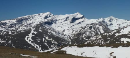
The first 2.5km of the ridge is broad and flat and provides easy walking to the first of the peaks, the Peñón del Muerto II. To the east, the view was restricted by the haze but it was just possible to pick out the 'Morróns' as well as the Sierra de Gador, and beyond to the coast at Adra. To the west however, in all their splendour, the mighty peaks of the main Sierra Nevada ridge demanded attention. At first they appeared distant but as the westerly breeze cleared the air, they grew in stature and the various valleys, ridges and peaks became sharper and more defined. They would draw my gaze for the remaining 8km of the ridge.

The main Sierra Nevada ridge from Loma de las Albardas
Continuing south we reached Peñón del Muerto I, from where the ridge narrows. The word Tajo on the maps means 'pile of rocks' and for the rest of the ridge we were to encounter LOTS of tajos. Some of these we simply picked our way through. Many of them however would have involved scrambling and more time than we had available so we by-passed them as best we could.

One of the many 'tajos' - Tajo de Breca
At over 10km, this is a very long and committing ridge. But finally, the end was in sight. From a distance the Peña de los Papos and its lieutenants appeared as a snow-covered jumble of broken rock. But surely not? Snow at 2,500m? The 'white' turned out to be the sun's rays reflecting off the schist rock. At first, the route to the summit appears impossible, but a feint path traverses the west flank and rises below the huge slabs, eventually reaching the summit at 2,533m, marked with a survey post.
")
Peña de los Papos (far left)
We were now 1,000m and almost directly above Trevélez. A steep descent was inevitable. Leaving the summit in a southerly direction, we dropped down to the col just north of Pico Fuentefrío. Turning due west we picked up a path skirting a pine forest and then found our way through open pastures, avoiding the curious gaze of their resident cattle. Eventually, tired and thirsty, we arrived on the well-trodden GR7 path and another half an hour saw us back in Trevélez for some much-needed rehydration before heading home to Salobreña.
My GPS recorded a total of 35.7km with 2,024m of ascent. Total 'moving' time was 10 hours 40 minutes. Due to its length and limited opportunities to bale out, I doubt the ridge is walked very often. For me though the reward for the effort was the breath-taking views of the main Sierra Nevada peaks, ever-present on my right hand side - simply splendid!

Google Earth Track
Ian Tupman March 2016