So there we were, loaded up with 5 days of equipment and food. Richard, of Spanish Highs Mountain Guides, dropped us off at the trailhead near the Ventura Hut at 2250m above the town of Lanjaron in the Alpujarra region of Andalucia, Spain.
The skies were blue and clear as we made our way onwards. There was a real feeling of "getting away from it all". Within 15 minutes we arrived at the ruined Ventura Hut. Pushing on, we climbed steadily uphill for a further 3.5 hours before arriving at the Laguna de Caballo where we stopped for the night.
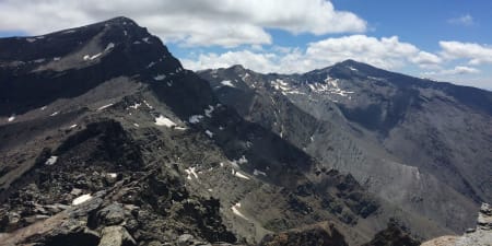
This is an ideal situation. The small lakeside location provides bivouac shelters with magnificent views of the Lanjaron valley northwards towards Veleta. Before settling down for our evening meal we made the steep climb up the Cerro de Caballo, a 300m ascent from the lake.
Next morning was glorious as we ascended to the col north of Caballo and trekked along the ridgeline passing over the peaks of Tajos Altos and the Cartujo. Then, after a short scramble, we reached the Elorietta refugio, a ruined hut. Patches of snow were met and instead of traversing the ridge of Tajos de la Virgen we descended leftwards (NW) towards the Lagunillas. Here there was sections of steep and hard snow requiring the use of crampons and ice axe. This is a bad spot in avalanche conditions.
This was followed by a steep ascent up an old ski piste before arriving at the Cariguela Hut, a pleasant spot to spend the second night out perched on the Col de Caiguela below the peak of Veleta. The hut has places for about 20 people. It had been a very hard day of 8hrs trekking, involving much ups and downs.
Day 3 was spent getting to the marvellous campsite of Siete Lagunas. This was an easy enough walk along the old road, a mild ascent of Loma Pelada and a descent to the Laguna de la Caldera. Unfortunately the ascent of the west flank of Mulhacen still had to be done. Mulhacen is the highest mountain in Spain at 3481m, and it certainly felt it as we slowly and breathlessly plodded our way up the steep hillside!
Arriving at the summit the clouds came in and the achievement was somewhat tainted. We descended the east ridge to Siete Lagunas in thick mist and some light rain. Overnight light rain fell steadily.
What a difference when we woke the following morning! Clear skies and the rising sun shining directly into the tent. Fantastic. After a quick breakfast we were off at 8am with light packs to bag the summit of Alcazaba, the 3rd highest summit here at approx 3200m. Lots of easy angled snow up to the summit followed by an exciting descent through the crags to the highest of the 7 Lakes (Siera Lagunas). An easy walk back brought us to the campsite. A rapid packing of gear followed and then we were off again, skirting Alcazaba's east face and heading over the Puntal de Vacares to the Laguna de Vacares where we stopped for the night.
This is a lonely, eerie spot. Very cold and isolated. I was glad next day when we started walking again. On over the remaining mountains we trekked until we reached the final 3000m summit, the Pico de Jerez. I don't remember the descent because it is long, tiring and never ends! We passed the Postero Alto hut and continued on for another 2 hours before we reached the town of Jerez de Marsquesado at dusk, where our transport was duly waiting to take us on the 2 hr drive back to Lanjaron for a few (many) vinos.
A great traverse. Hardly saw anybody in the 5 days. I can imagine this is a great winter trip? Much more difficult so my mates and I I will be heading back March 2009. The feeling of remoteness combined with the brilliant views made this a trip to remember.
By Robert Sharp (May 2008)
References: