A report of an ascent in March 2021 of the Corazon de la Sandia by Richard Hartley of Spanish Highs
This is a superb mountain day out to one of the finest summits in the Sierra Nevada region. Thoroughly recommended if you are in the Granada region as a day hike.
The very name strikes fear into the heart of every mountain adventurer. Well it does until they realise that Corazon de la Sandia actually means "Heart of the Watermelon" in spanish. Somewhat deflates the whole thing eh? But fear not, this is a proper mountain. It's situated in the Cumbres Verdes range west of the Sierra Nevada and is a fine mountain with a sting in the tale when you arrive near it's lofty, rugged summit.
Our route
- Distance: 15km
- Ascent: 1174m
- Hours: 7 hours
- Map of route
- GPX download
- Full Photo Album Smugmug
"Corazon de la Sandia has to be in my top 5 summits of the Sierra Nevada region!"
Richard Hartley
The Walk
This walks starts from the Rio Dilar trailhead, east of the town of Dilar near Granada. Follow the "Rio Dilar" signposts through the town to arrive in 10 minutes at the recreational area where there is a large car park.
Then proceed east along very good wide tracks until the track forks and a bridge on the right crosses the Rio Dilar and gives access to the valley of the Barranco del Rambla Seca.

Start of the walk along the Rio Dilar
A Rambla in spanish means and arid or semi-arid dry watercourse. Ramblas only have water flowing during or after heavy rainstorms.
The Rambla Seca is impressive at least in its initial stages. Huge cliffs tower overhead and the valley is only in parts a few metres wide. After this it opens out. Climb slowly up the valley floor. The going is quite easy and altitude is gained quickly for little effort.

In the Barranco de Rambla Seca looking up to Boca de la Pesca
But the valley is long. It took us the best part of two hours to eventually emerge from the forested sides onto the open hillsides.

Emerging from the tree line in the Barranco de Rambla Seca
Here the character of the route changes. We have arrived in wild west terrain. The advice is to keep to the paths as any diversions off track lead invariably to steep and loose terrain. Good footwear is thus essential for this walk!
The ridgeline between Picacho Alto and Puntales del Tigre is reached. Turn east here and follow the ridge towards Puntales del Tigre. We ascended the ridge direct direct to the summit of Puntales del Tigre but it is very steep and loose. A better plan is to take the track leading off to the right a few hundred metres from the top. This leads easily to the col between Corazon de la Sandia and Puntales del Tigre.

The col between Puntales del Tigre and Corazon de la Sandia

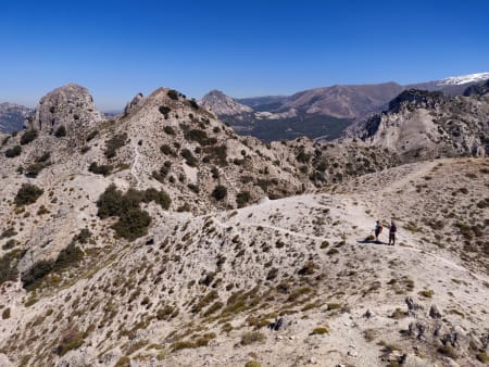
At the col between Puntales del Tigre and Corazon de la Sandia
It's an impressive view from this col. Yes, there is the ever present backdrop of the Sierra Nevada but the best views are clsoe by. The dramatic ridge of Alayos del Dilar and of course the spectacular summit of Corazon de la Sandia hold the eye.
Its now a short walk to the col before the summit of Corazon de la Sandia.
At the col the realisation dawns that to reach the summit of the peak does actuallly involve some scrambling. The scrambling involved is generally very easy but there are one or two places on the ascent (and descent!) that will give pause for thought and make you think.
The actual summit is small, sharp and compact with magnificent views in very direction. Must do a wild camp up here!
The nervous might be well advised leaving the summit for another day and be content with a superb lunch spot perched on the col and surrounded by steep rock walls. For some reason this spot always reminds me of the Cuillin ridge on the Isle of Skye.

Puntales del Tigre from the summit of Corazon de la Sandia

Looking down from the summit to the col

From the summit looking east towards Puntal de los Mecheros and the Sierra Nevada
After taking in the splendid delights of the Corazon, we retrace our steps back along to the col between Puntales del Tigre and Picacho Alto.

Start of the descent from the col at Puntales del Tigre
At this col turn north and drop down to gain a traverse path that leads north west around Picacho Alto itself to gain a pass on its far side. This path is really nice. The views over to Granada are amazing and it feels like some spectacular alpine trail we are following.
At the pass at the far side of Picacho Alto a well graded zig zag path drops down through the arid wastelands to reach forest roads which are followed very easily back to the start point.

The forested hills on the descent that lead to Silleta de Padul

Descent to the forest tracks and finish point