Ian Tupman, describes an hike to the summit of Trevenque in the Cumbres Verdes, a wonderful peak in the foothills of Spain's Sierra Nevada mountains
Not having done any serious hill walking in February and March, I wanted to get out and do a good leg and lung-stretcher before returning to the high peaks of the Sierra Nevada. Trevenque had been mentioned to me in the past by Spanish Highs and it sounded just what I was looking for.

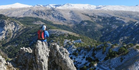
Looking up the west ridge to Trevenque summit
Trevenque is located approximately 11 kms to the west north-west of Veleta and at 2,083m, it is significantly lower. It is however higher than the peaks which surround it and is an impressive looking lump of rock when approached from the west.
I parked the car at the Collada de Sevilla having followed the excellent directions given in this thread. The un-surfaced section of the access road is slightly rutted in places but with care, it can easily be negotiated without a 4x4 vehicle. Heading away from the car park, the signed path took me around to the south side of the ridge but I wanted to walk along the ridge itself. Just before an information board there is a feint path on the left which cuts across and then climbs to the ridge line. An alternative is to continue on the marked track which contours eastwards below the ridge and provides a more gentle ascent to the foot of the final climb to the summit.
The ridge, or Cuerda del Trevenque as it is shown on the map, is an interesting roller coaster of limestone peaks and the well-worn path is easy to follow. In some places it descends to meet the lower track and then climbs away again. After approximately 3kms, the path rises steeply up a loose, stony ridge and the lower track swings away to the south-east. The final ascent to the summit takes you through some interesting rock formations and the summit itself comprises a series of individual ‘tors’, all of which are worth exploring as each gives a different perspective of the true summit. The backdrop of the snow-covered Sierra Nevada (albeit with less snow than usual) was stunning and the 360 degree panorama is well-worth the effort required to get up there.
The descent down the east side is initially on steep and very loose limestone gravel. Care is needed and a pair of walking poles is recommended. At the Collado de Martin there is the option of turning south-west and returning to the car park via the dry river bed of the Canal de Espartera but I wanted to visit the botanical gardens shown on the map to the north-east of Trevenque. The forest road, which initially heads north, is in very good condition and passes through lovely pine forest which, I am pleased to report, appears to be free of the pine processionary caterpillar which is currently devastating forests to the east. Good news for dog walkers!

Descending loose ground east to the Collado de Trevenque
The botanical gardens were open when I got there but they have quite limited opening times and if planning a visit, I would suggest checking by telephone first.
From the gardens I continued west along the 6km of forest road to arrive back at the car park. With legs and lungs duly exercised, it was time for some throat lotion and the restaurant bar at the Cortijo del Hervidero obliged with a lovely cold pint of it.