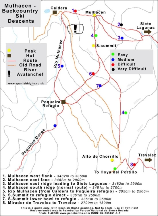
Mulhacen is a magnificent ski touring peak. What ski descents are available for backcountry skiing enthusiasts? As can be seen from our trail map below, there are options for all grades of skier. Easier ways for the beginner or for marginal snow conditions, and tougher runs for the more experienced on good days.
Most 2 day ski tours will overnight either at the Refugio de Poqueira (guarded), or the Caldera refugio (unguarded), or even wild camp at Siete Lagunas.

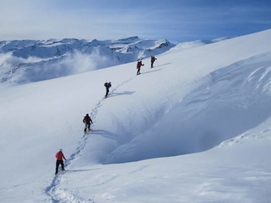
Heading up Mulhacen, Sierra Nevada
Descents are the "interesting" part of any ski tour. Will it be a headlong, exhilarating dash down the mountainside on perfect snow or will we be getting exasperated with the changing crud, ice, breakable crust and slush? Will we be back at the hut in 20 minutes or in 90? Mulhacen has the ability to deliver all of these and more. Below our trail map we describe 8 of the main descents.
Note. It goes without saying that on every ski tour axe, crampons and helmet should be carried and used if necessary! If you are planning a trip to the Sierras then please contact us at Spanish Highs Mountain Guides. We can advise on current mountain and snow conditions, access points, route choice and even provide gear and equipment hire.

Mulhacen ski descents
Mulhacen west flank
Starts just 100m south of the summit cairns. Can be very icy until mid height on the descent as high winds tend to scour the top half of surface snow. At times, when the ice is continuous or transparent, then leave well alone. There have been accidents here in similar circumstances. When the whole face is complete with fresh powder it gives a fantastic run down to the Caldera. Make sure you keep well to the right of the avalanche area marked on our map. It is tempting to "cut the corner". The advice is don't.
Mulhacen east face
A difficult but enjoyable run in the right conditions. Start anywhere south of the summit and before the start of the east ridge. Head down continuously steep slopes. We only do this in perfect snow conditions (there can be an avalanche risk on some sloping slabs lower down on the left), so it is usually a rapid trip down to Siete Lagunas. One always gets the feeling it's over too quick at times! From there the options are down to Trevelez or re-apply the skins and contour round the east flank of Mulhacen at around the 3000m level, linking up to the south ridge.
Mulhacen east ridge leading to Siete Lagunas
Easy angled for the most part. No avalanche dangers and normally good snow as is on leeward side of the normal prevailing weather systems. You may have to keep well right at times to find the best snows. The steep drop off north to Siete Lagunas is possible in places but can only be recommended to the experienced. From the ridge 75m above Siete Lagunas, options exist to Trevelez or southwards back to the south ridge at 3000m.
Mulhacen south ridge (normal route)
After heavy snows this is the only safe route until consolidation of the snow pack occurs. Easy angled throughout, it is nevertheless a long and fine outing. If heading for the Hoya del Portillo, the boring trudge from the Mirador de Trevelez south is more than made up for by the thrill of the descent through the trees at the end of the day back to the Hoya del Portillo or beyond if the snow allows.
Rio Mulhacen (from Caldera to Refugio de Poqueira)
An extension of the west flank descent or useful if you have been ski touring on Loma Pelada or the Puntal de la Caldera. Head south from the Caldera hut and give the lower part of Mulhacen's west face a wide berth by heading out west (see avalanche area on map). Then go where the snow is. There is normally plenty throughout the winter, and a lot of it too, as the wind blown snow off the tops tends to congregate here. Enjoy the descent down the Rio Mulhacen (buried of course) until the 2500m level, when a escape left contouring the hillside can be made. Just round the corner the welcoming Refugio de Poqueira is reached.
South summit to Refugio de Poqueira direct
Difficult to find the start point on first acquaintance. Not to be used in mist unless extremely confident. From the trig point at the south summit keep west of the ridgeline and drop into the shallow bowl that is actually the line of the main summer access path. Descend some 50m. To the south west, steepening snow slopes can be seen. This is in a direct line to the Poqueira hut. Take these slopes which converge and steepen. There is a levelling out as the remnants of the old road are crossed. Below and to the left are a line of small cliffs. The way direct to the Poqueria hut takes a line just to the right of these. In no time at all you will be enjoying a jug or two of vino caliente!
South summit lower bowl to Refugio de Poqueira
An easier and less steep option than the above route, although care should be taken to identify the correct start point where the south ridge is left. From the south summit go east to find the best snows before contouring back south and finally south west to rejoin the main south ridge. The start is at about 3000m and takes a line down the bowl right of the south ridge. This is at the foot of a steeper section of the ridge where the slope angles ease. There is a short steeper section and then cruising skiing south west. Make note of some prominent rocks lower on the right. You will need to keep well left of these. The slope steepens and the hut can then be clearly seen. Descend where you can. If late in the season there is a narrow but reliable shallow gully always filled with skiable snow slightly to the left. This leads down to the Poqueira hut access track. Follow this right for 200m back to the hut.
Mirador de Trevelez to Trevelez
Ok. Not strictly Mulhacen, but worth including if the snows lie thick and deep. The ski route follows the line of the summer access track from Trevelez, and starts at the Mirador de Trevelez. Head down in an easterly direction. Can be quite testing in marginal snow conditions or mist. It is however, one of the most rewarding of the Sierra Nevada ski descents. You may well have to be quite ingenious lower down to keep linking snow. There is nothing quite like coming back down to a village at the end of a good day in the hills though. The local camposinos might well think you are a creature from another planet as you trudge your way in ski boots through the high parts of the village on your way to a well earned beer!
You are welcome to come and experience the backcountry ski touring on Mulhacen and the Sierra Nevada between December and May inclusive each year. We also provide transport and accommodation for self guided groups.
