Describes a 3 day trek between Bayárcal and Trevelez on the long distance path, the "Sulayr", around Spain's Sierra Nevada National Park
Thanks to Ian Tupman (and Meg of course!) for the following report detailing their experiences._
N.B Spanish Highs support sections of this route either guided or self guided.

The marker post that would be our 'wayside companion' for three days
Our border collie, Meg, is now fourteen months old. When we got her, the intention was that she would come with me on longer walks when she was older. During the winter, she accompanied me on several ski touring and snowshoeing days and so, with the longer days of late spring upon us and a receding snowline, I decided it was time for our first multi-day trek together. Not knowing how she would deal with wild camping, I thought a three day/ two night trip would be a good introduction.
But where to go? With the Sierra Nevada pretty much on our doorstep we are spoilt for choice, but after pouring over the maps, I decided to plump for part of the GR-240 Sulayr which, at 300km, is the longest circular walk in Spain and at an average altitude of around 2,000m. I am familiar with most of the western end of the Sierra Nevada but I had never ventured east of Trevélez. Having read the route descriptions in the guide book (Editorial Penibetica 'Sendero Sulayr'), I decided on the three sections between Bayárcal and Trevélez. This would give a total distance of just over 62km and a cumulative ascent of just 1,600m, a relatively gentle itinerary for our first trek. The guide book gives the route in an anti-clockwise direction, but we would be walking clockwise, providing a test for both my navigational and Spanish-English translation skills.
DAY ONE
With fair weather forecast for the next three days, I arranged with Spanish Highs Mountain Guides to be dropped off at our start point, some 6km to the north of Bayárcal. The initial section took us through a lovely oak forest before we descended to the Arroyo del Palacón and crossed the river into Granada province.
From there, we climbed steadily through a pine forest to reach the track (carril) which we would follow for the next 15km. Shortly after joining the carril, I was aware of movement in the trees to my right and three wild boar (jabali) ran past me. In the same moment, Meg spotted them and set off after them. Thankfully her recall is pretty good and with a look of disappointment, she returned to my side.

El encinar de Bayárcal
After 4km we reached the Área Recreativa Río Laroles, a shaded picnic area next to the river which would make an ideal overnight spot. Turning south and climbing gently on the carril, we then turned north into the Río Nechite valley. After topping up with water from the river, we ascended again to reach the Fuente del Espino, the 'official' end of today's section. A derelict cortijo, signs of jabali in the trees and no water supply ruled this out as a camping spot so, I decided to continue and we climbed up to the Peñón de la Loma in search of a better option.
From the ridge, I could see a couple of cortijos on the other side of the valley some 2km away, close to the Río de Valor and with flat ground around them. One of the cortijos was obviously derelict and so I pitched the tent in front of it, knowing it unlikely that we would be disturbed.

First night's camp
I had covered 24km, Meg, probably double that, but it had reduced the next day's distance to only 13km. Fed and watered, we turned in for an early night and I fell asleep to the chirping of the birds in the nearby bushes.
DAY TWO
We had a leisurely start with breakfast taken in the morning sunshine. After the previous day's 15km on the hard surface of the carril, it was good to get onto open ground and reaching the broad ridge of the Sierra del Morrón brought superb views to the west and the snow-covered peaks of Mulhacén and Alcazaba.

Looking west from the Sierra del Morrón
From there, a gentle traverse brought us down through another forest and along a good path to cross the Río de Mecina. 50m north of the river crossing is a superb spot to camp but we had to move on. Water bottles were topped up, feet and paws were cooled off and we climbed up the west side of the valley to reach the acequia vieja. Just beyond is the Aprisco de Mecina, a seemingly abandoned cortijo and another potential overnight spot.
Our route then took us south-west along the approach track from the cortijo for 4km, passing through shaded pine forest. Crossing a wide fire-break, we arrived on the ridge just to the north of Cerro Gordo and then dropped down to join another carril at Lastonar.

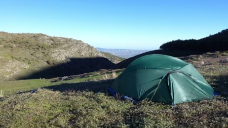
Camp Two and the view south to the Contraviesa and the Mediterranean
As with the previous day, there was nowhere suitable to camp and it was necessary to carry on in search of an overnight spot. 7km later and with sore feet, we arrived at the Cortijo de las Angosturas. The terraced land in front of the cortijo is an ideal camping spot with fantastic views up and down the Río Chico valley. I pitched the tent and we had our evening meals as the sun dropped down behind the ridge.
As dusk fell, I could see cattle descending the hillside on the east side of the valley, the clanging of their bells attracting Meg's attention. A splinter group broke away, crossed the river and within minutes they were chomping on the grass 50m from the tent. They had to be moved on and with no pastor looking after them; I decided Meg's natural herding instincts should be called upon. She responded perfectly to my whistle and commands and together we convinced the cows to about turn and drove them back across the river to rejoin the herd. Relaxed in the knowledge that we wouldn't be trampled to death in the night, I closed up the tent and dropped off to the soothing chimes of the cows' bells brought across the valley on the breeze.
DAY THREE
The additional 7km on the previous day had reduced today's tariff to 17km and after breakfast in the sunshine, we headed due south along the carril on the west side of the Río Chico valley. The valley is fed by numerous watercourses and has been cultivated to a much greater extent than any of the other valleys we had walked through. It was interesting to see new investment in enclosures with hi-tech framing and wires, presumably for beans or possibly grapevines.

New investment in agriculture in the Río Chico valley
After 7km on the track, we reached the turn off which took us up through a pine forest (with another good camping spot) and out across the Loma de las Alberquillos to El Portichuelo from where there are grand views from the east, round to the north-west.
Turning north, we started the descent into the Río de Trevélez valley. Height is lost quickly on the zig-zag path and through the trees we got sight of our objective, the village of Trevélez which, at 1500m, is reportedly the highest village in Spain. The GR-240 shares the last 3km of this section with the GR-7 and we met our first fellow walkers, a couple en-route from Trevélez to Bérchules.

Trevélez and journey's end
Half an hour later, we arrived at the roadside just below Trevélez. Meg was attached to her lead for the first time in three days and we walked the last 400m up into the square to be greeted by our retrieve team from Spanish Highs. We enjoyed drinks and some tapa together in the early afternoon sunshine before returning to Lanjarón and then home to Salobreña for baths and a well-earned rest.
OBSERVATIONS AND RECOMMENDATIONS
Way marking The way marking varies from excellent to poor. Although the guidebook states that the walk can be done in either direction, the way marking has definitely been done assuming an anti-clockwise direction of travel. Travelling clockwise, as we did, there are several places, where the route leaves a carril, that are poorly marked and are easily missed. And within the forest sections there are occasional marker posts, supplemented with red and white marker stripes on some trees, but these are often only visible if travelling anti-clockwise and on several occasions we came off the route. However, knowing that we needed to be at a certain point on exiting the forest, it was possible to make our own way out.

OK, so where next?
Overnight stops I am fairly certain that the route was planned assuming walkers will descend to the nearest village or town at the end of each stage; there can be no other explanation for some sections finishing on a forest track with no suitable place to pitch a tent or even obtain water. Descending 500m or so from these locations at the end of a long day, with the prospect of having to ascend again in the morning is less than attractive and so camping or bivi-ing are the only realistic options. My recommendation therefore, is not to plan an itinerary around the starts and finishes of the various sections, but around likely camping spots and sources of water.
Pine Processionary Caterpillars All of the pine forests through which our route passed are affected by the pine processionary caterpillar. The white nests or bolsas in the trees contain the caterpillars which fall onto the ground. Their defence mechanism is to release hundreds of small hairs from their bodies, which, if they are inhaled by a dog can be fatal. Humans can have serious reactions as well so I would recommend avoiding the late winter and early spring if considering this route. NB. The above comments relate to the three sections of the GR-240 that we walked and may not be applicable to the rest of the route.
Ian Tupman May 2013